   |
|
  |

![]()
![]()
![]()
![]()
![]()
![]()
![]()
![]()
![]()
![]()
|
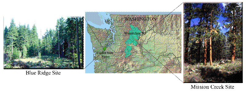
Project OverviewOriginal proposal in PDF format Fire researchers and managers are dependent upon accurate, reliable, and efficiently obtained data for the development and application of crown fire behavior models. In particular, reliable estimates of critical crown characteristics, including crown bulk density, canopy height, crown base height, and canopy closure are required to accurately map fuel loading and model fire behavior over at the landscape scale. The emergence of a new generation of high-resolution remote sensing systems in recent years, as well as the development of more accurate field measurement techniques, allow for more accurate and efficient estimation of crown fire behavior variables. With spatial resolutions often less then one meter, the spatial data provided by these sensors can support more detailed measurement of the forest canopy structure. Analytical techniques and associated software were developed to automatically and efficiently extract the required information from the enormous quantity of data provided by these high-resolution remote sensing systems. Project Objectives, Study Sites, and DatasetsWe carried out an extensive investigation of the utility of A) active infrared scanning (LIDAR) sensor data and B) active microwave (interferometric synthetic aperture radar, IFSAR) sensor data for this application, and C) compared remote sensing estimates with field-based techniques for the estimation of crown fire fuel density, type and condition. Two sites were used: 1) mixed-conifer [ponderosa pine (Pinus ponderosa), Douglas-fir, grand fir (Abies grandis)] stands in the Mission Creek Fire/Fire Surrogates study site in Wenatchee National Forest in the eastern Cascades of Washington State; and, 2) 70-yr-old second growth stands dominated by Douglas-fir (Pseudotsuga menziesii), western hemlock (Tsuga heterophylla), and western redcedar (Thuja plicata) in the Blue Ridge area of Capitol State Forest in western Washington State (Figure 1).
Figure 1. Location of study areas. (Photo credits: Blue Ridge: Gordon Bradley (University of Washington), Mission Creek: http://www.fs.fed.us/ffs/slideshow.html) The Mission Creek site is one of thirteen (13) Fire and Fire Surrogates (FFS) sites distributed nationwide and designed to investigate the economic and ecological effects of fire and fire surrogate treatments in a number of different forest types and conditions in the United States (FFS Project Executive Summary). This site contains twelve (12) treatment units (3 thinned and burned, 3 thinned, 3 burned, and 3 control), where six (6) 20 m × 50 m vegetation plots were established within each unit (Figure 2). In this project, highly accurate (~ 1 m error) positions were established for these plots using a differentially corrected GPS and laser surveying instruments in 2003 and 2004.
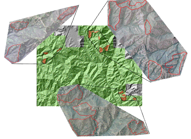
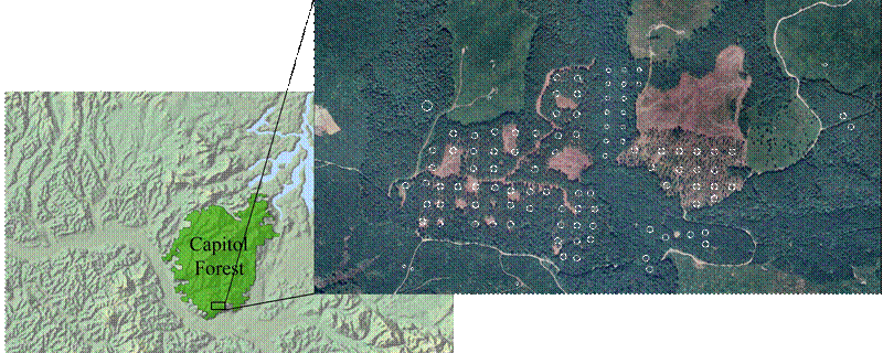
Figure 2. Mission Creek FFS study site (general location and individual orthophotographs of each treatment unit). The Blue Ridge area is the site for an ongoing silvicultural trial investigating the effects of several different harvest treatments designed to create a variety of different residual stand densities: clearcut [0 trees per ha (TPH)], heavily-thinned (40 TPH), lightly-thinned (175 TPH), and control (280 TPH). A systematic grid of 101 inventory plots was established across a range of different stand types in this study area. These plots were georeferenced as part of a high-accuracy topographic survey carried out in 1999 (figure 3).
Figure 3. Orthophotograph of Blue Ridge study site. White circles indicate ground plots. Both study sites are mountainous, with elevations ranging from 150 to 400 meters at the Blue Ridge site and 650 to 1500 meters at the Mission Creek site. On both sites high-resolution LIDAR and IFSAR datasets were acquired using commercially available sensors flown in fixed-wing aircraft. Ground plot data were collected at both sites and these datasets were then analyzed to determine if a suite of remotely sensed variables were significantly correlated with ground measured canopy fuel variables at the plot level. |
|
|