   |
|
  |

![]()
![]()
![]()
![]()
![]()
![]()
![]()
![]()
![]()
![]()
|
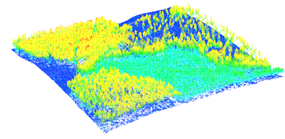
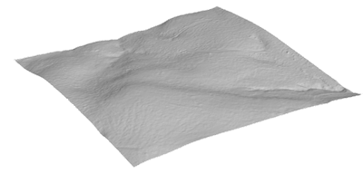
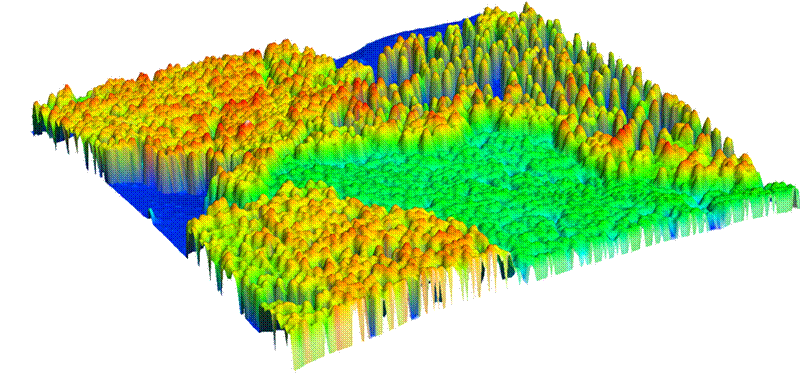
LIDAR & IFSAR TOOLSA major component of this project was the development of specialized remote sensing software systems that could efficiently process, analyze, and display the extremely large LIDAR and IFSAR datasets that were acquired over the study sites. For instance, there are 40 million data points in the LIDAR dataset covering the 2 square mile Blue Ridge study site and approximately 10 times this amount of data covering the Mission Creek site. Commercial remote sensing packages did not have the capacity to handle such large datasets. FUSION LIDAR/IFSAR data conversion, processing, and display software suiteTo address this need, a LIDAR/IFSAR data conversion, analysis, and display software suite, known as FUSION was developed (McGaughey and Carson, 2003). FUSION allows 3-dimensional terrain and canopy surface models and LIDAR/IFSAR data to be fused with more traditional 2-dimensional imagery (e.g., orthophotographs, topographic maps, satellite imagery, GIS shapefiles). FUSION processes raw LIDAR data into a number of vegetation metrics. Canopy- and ground-level surface models can be produced; and then, by simple differing, canopy height models can be generated (Figure 8) FUSION includes algorithms that allow the user to manually measure individual tree attributes or use automated capabilities to characterize individual tree attributes over large areas (McGaughey et al., 2004).
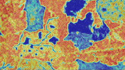
Figure 8. Raw LIDAR point cloud (a); LIDAR-derived terrain model (b); LIDAR-derived canopy surface model (c), Blue Ridge site. FUSION technology transferFUSION is publicly available worldwide through the internet. Canopy Fuel Estimator—CFE Fuel characterization using airborne laser scan dataTo assist resource managers in the use of LIDAR to characterize canopy fuels over the landscape, a LIDAR processing tool titled the Canopy Fuel Estimator (CFE) was developed. The overall objective of the Canopy Fuel Estimator (CFE) is to use data from airborne laser scanner (small-footprint LIDAR) systems to characterize fuel conditions over extensive land areas. The primary reference for the methodology is Andersen et al. (2005b). Processing is accomplished in a raster environment using input layers and ground surface models derived from LIDAR point data. While the CFE is primarily designed to estimate canopy fuel parameters, its design is flexible enough to support a variety of analysis tasks that involve LIDAR point data, production of data layers derived from the point data, and, optionally, application of a “model” to predict a variable of interest. CFE overviewCFE computes LIDAR-derived variables for the maximum, mean, and coefficient of variation of the LIDAR canopy heights, several quantile-based metrics describing the LIDAR canopy height distribution, and a canopy density metric. The CFE includes models that use these LIDAR-derived variables to predict canopy fuel weight, crown bulk density, canopy base height, and canopy height over the landscape. Models included with the CFE are applicable to forests in western and eastern Washington. Additional models can be defined using a combination of LIDAR-derived metrics and either pre-defined or user-supplied model forms. The CFE reads industry-standard LAS LIDAR data files and produces raster output that is compatible with most Geographic Information System (GIS) environments. The CFE is designed as a stand-alone program that uses a graphical interface to guide the user through data processing and analysis. CFE is designed in such a way that it can be “connected” to ArcMap at a later date. This connection will most likely consist of adding a menu option or button to ArcMap that launches the CFE and providing the ability to create an ArcMap project that includes the input data, intermediate data products, and final outputs as layers in the project. The CFE will perform its own processing without relying on ArcObjects but will interact with ArcObjects to access and manage the ArcMap project. Output from the CFE is a series of new spatial data layers that describe fuel characteristics and the distribution of forest canopy over the project area (Figure 9).
Figure 9. Canopy fuel maps (30 m resolution), Blue Ridge site. LIDAR-derived canopy metrics and canopy fuel layersThe LIDAR points used for all derived canopy metrics is the set of LIDAR returns that are 2 meters (user defines this canopy threshold height) or more above the LIDAR bare-ground surface. This subset of LIDAR returns represents “vegetation points”. The following variables are computed from the raw LIDAR point data and the bare-ground surface model.
The following spatially explicit canopy fuel layers are generated from the LIDAR-derived canopy metrics in a GIS-compatible raster format.
CFE metadataOutput from the CFE consists of a plain text report and an HTML report. The plain text report documents the input data, model set, and output layers. It contains enough information for a user could re-create the run if necessary. The HTML report contains all of the information from the plain text report but also provides links to images representing the input data and output layers. FUSION is used to automatically generate the images and image legends. CFE technology transferThe CFE is no longer supported. It was developed using earlier version of FUSION's tools and current versions are not compatible with the CFE. |
||||||||||||||||||||||||||||||||||||||||||||||
|
|